Discounted Products
-
 Leo Creation 144 TC Cotton Double Jaipuri Prints Flat Bedsheet(Pack of 1, Blue, Gree, Red, Grey, Light Grey)
Original price was: ₹2,999.00.₹329.00Current price is: ₹329.00.
Leo Creation 144 TC Cotton Double Jaipuri Prints Flat Bedsheet(Pack of 1, Blue, Gree, Red, Grey, Light Grey)
Original price was: ₹2,999.00.₹329.00Current price is: ₹329.00.
-
 Home Garage 210 TC Cotton King Floral Fitted (Elastic) Bedsheet(Pack of 1, Grey)
Original price was: ₹999.00.₹299.00Current price is: ₹299.00.
Home Garage 210 TC Cotton King Floral Fitted (Elastic) Bedsheet(Pack of 1, Grey)
Original price was: ₹999.00.₹299.00Current price is: ₹299.00.
-
 Goodrik 140 TC Cotton Double 3D Printed Flat Bedsheet(Pack of 1, Brown)
Original price was: ₹499.00.₹229.00Current price is: ₹229.00.
Goodrik 140 TC Cotton Double 3D Printed Flat Bedsheet(Pack of 1, Brown)
Original price was: ₹499.00.₹229.00Current price is: ₹229.00.
-
 GLOBALSHOP 350 TC Microfiber Double Floral Flat Bedsheet(Pack of 1, Multicolor)
Original price was: ₹1,250.00.₹263.00Current price is: ₹263.00.
GLOBALSHOP 350 TC Microfiber Double Floral Flat Bedsheet(Pack of 1, Multicolor)
Original price was: ₹1,250.00.₹263.00Current price is: ₹263.00.
-
 RisingStar 250 TC Microfiber King Printed Fitted (Elastic) Bedsheet(Pack of 1, FITTED-ROUND-CIRCLES-PREMIUM)
Original price was: ₹2,299.00.₹299.00Current price is: ₹299.00.
RisingStar 250 TC Microfiber King Printed Fitted (Elastic) Bedsheet(Pack of 1, FITTED-ROUND-CIRCLES-PREMIUM)
Original price was: ₹2,299.00.₹299.00Current price is: ₹299.00.
-
 Home Garage 210 TC Cotton King Floral Fitted (Elastic) Bedsheet(Pack of 1, Fitted Black Green)
Original price was: ₹1,299.00.₹299.00Current price is: ₹299.00.
Home Garage 210 TC Cotton King Floral Fitted (Elastic) Bedsheet(Pack of 1, Fitted Black Green)
Original price was: ₹1,299.00.₹299.00Current price is: ₹299.00.
-
 Home Garage 180 TC Cotton King 3D Printed Flat Bedsheet(Pack of 1, White)
Original price was: ₹999.00.₹229.00Current price is: ₹229.00.
Home Garage 180 TC Cotton King 3D Printed Flat Bedsheet(Pack of 1, White)
Original price was: ₹999.00.₹229.00Current price is: ₹229.00.
-
 Home Sizzler 153 cm (5 ft) Polyester Room Darkening Window Curtain (Pack Of 2)(Floral, Maroon)
Original price was: ₹799.00.₹299.00Current price is: ₹299.00.
Home Sizzler 153 cm (5 ft) Polyester Room Darkening Window Curtain (Pack Of 2)(Floral, Maroon)
Original price was: ₹799.00.₹299.00Current price is: ₹299.00.
-
 Panipat Textile Hub 152.4 cm (5 ft) Polyester Window Curtain (Pack Of 2)(Solid, Aqua)
Original price was: ₹1,899.00.₹299.00Current price is: ₹299.00.
Panipat Textile Hub 152.4 cm (5 ft) Polyester Window Curtain (Pack Of 2)(Solid, Aqua)
Original price was: ₹1,899.00.₹299.00Current price is: ₹299.00.
-
 Home Sizzler 214 cm (7 ft) Polyester Semi Transparent Door Curtain (Pack Of 2)(Floral, Maroon)
Original price was: ₹1,199.00.₹399.00Current price is: ₹399.00.
Home Sizzler 214 cm (7 ft) Polyester Semi Transparent Door Curtain (Pack Of 2)(Floral, Maroon)
Original price was: ₹1,199.00.₹399.00Current price is: ₹399.00.
-
 Home Sizzler 153 cm (5 ft) Polyester Room Darkening Window Curtain (Pack Of 2)(Floral, Brown)
Original price was: ₹799.00.₹299.00Current price is: ₹299.00.
Home Sizzler 153 cm (5 ft) Polyester Room Darkening Window Curtain (Pack Of 2)(Floral, Brown)
Original price was: ₹799.00.₹299.00Current price is: ₹299.00.
-
 Stella Creations 214 cm (7 ft) Polyester Room Darkening Door Curtain (Pack Of 2)(Abstract, Brown)
Original price was: ₹1,299.00.₹449.00Current price is: ₹449.00.
Stella Creations 214 cm (7 ft) Polyester Room Darkening Door Curtain (Pack Of 2)(Abstract, Brown)
Original price was: ₹1,299.00.₹449.00Current price is: ₹449.00.
-
 Homefab India 152.5 cm (5 ft) Polyester Room Darkening Window Curtain (Pack Of 2)(Floral, Light Blue)
Original price was: ₹1,199.00.₹319.00Current price is: ₹319.00.
Homefab India 152.5 cm (5 ft) Polyester Room Darkening Window Curtain (Pack Of 2)(Floral, Light Blue)
Original price was: ₹1,199.00.₹319.00Current price is: ₹319.00.
-
 Urban Home 214 cm (7 ft) PVC Transparent Door Curtain Single Curtain(Solid, Off White)
Original price was: ₹699.00.₹203.00Current price is: ₹203.00.
Urban Home 214 cm (7 ft) PVC Transparent Door Curtain Single Curtain(Solid, Off White)
Original price was: ₹699.00.₹203.00Current price is: ₹203.00.
-
 Panipat Textile Hub 213 cm (7 ft) Polyester Door Curtain (Pack Of 2)(Solid, Brown)
Original price was: ₹1,199.00.₹349.00Current price is: ₹349.00.
Panipat Textile Hub 213 cm (7 ft) Polyester Door Curtain (Pack Of 2)(Solid, Brown)
Original price was: ₹1,199.00.₹349.00Current price is: ₹349.00.
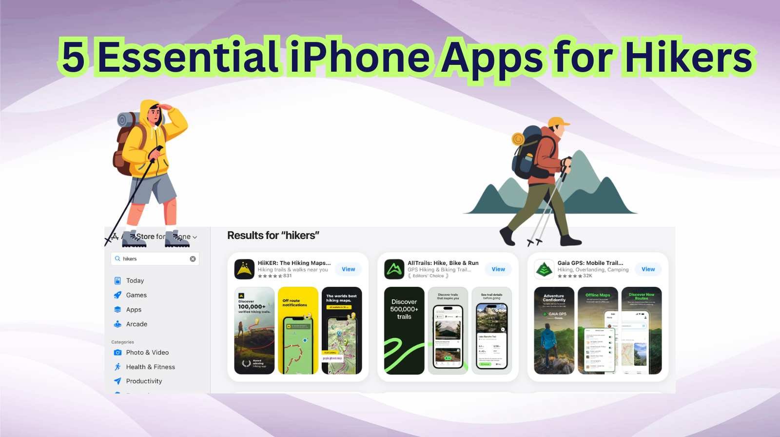
Hey friends, I’m Jessica — and whether I’m planning a weekend trail jaunt, a multi-day back-country trek, or just a relaxed nature walk with my dog, my iPhone has become one of my most trusted outdoor companions. While there’s nothing that replaces solid boots, a map, and a compass, the right apps make hiking easier, safer, and more rewarding.
Today I want to share five essential iPhone apps every hiker should consider — whether you’re new to the trails or a seasoned path-finder. These apps cover navigation, offline maps, weather updates, trail discovery, and photo journaling. Let’s dive in.
1. AllTrails: Trail Discovery and Navigation
One of my go-to apps when I’m scouting new hikes. AllTrails boasts an enormous library of hiking, running, and biking trails, with user reviews, photos, and detailed maps. (App Store)
Why I love it:
- You can search by difficulty, length, elevation gain — perfect for planning a family hike or a serious summit.
- The app supports offline map downloads, so even when you’re off-grid, you’re good.
- Built-in GPS tracking lets you log your route and share it with friends or family.
- Filters like “kid-friendly”, “dog-friendly”, or “stroller-friendly” let you pick the right trail vibe.
Pro tip: Before heading out, load the map for the trail while you have cell service. Download offline. Make sure your phone is fully charged. I always carry a small power bank just in case.
What to check:
- If you go off the beaten path, check reviews for mobile-signal strength or trail condition notes.
- Enable “Notify me when I leave trail” if available — helps avoid unexpected detours.
2. Gaia GPS: Advanced Topographic Mapping for Serious Trips
When I’m going beyond well-marked trails into more remote terrain, Gaia GPS comes into its own. It offers detailed topo maps, multiple map layers, and tools suited for longer treks. (Traveling Nature Journal)
Standout features:
- Downloadable map tiles for offline use in areas with no signal.
- Elevation profiles, route planning, waypoints, and the ability to import/export GPX files.
- High-level detail for wilderness areas that general hiking apps might miss.
Why use it: For back-country, overnight trips, or when you’re forging your own route, this is the app I rely on. If your hiking style is exploratory rather than simply following established trails, Gaia GPS is worth the learning curve.
My tip: Before you leave, spend 15 minutes in the app to mark your starting point, set a waypoint for your turn-back time, and screenshot key map sections just in case your phone shuts down.
3. Windy (or a strong weather-app alternative): Plan Your Conditions Ahead
Weather can change fast in the mountains or forest — and your hike’s safety often depends on your awareness of conditions. While there are multiple weather apps, I find Windy (or any premium weather app with terrain overlays) invaluable.
What it gives you:
- Hour-by-hour forecasts including wind, rain probability, and cloud cover.
- Animated map overlays showing storms, wind direction, and temperature gradients.
- Synchronization with the terrain you’ll walk — helpful when heading into higher elevations.
Why this matters:
Even if your trail is moderate, a sudden wind shift or rainstorm can make the difference between a fun hike and a tricky descent. I check Windy the night before and the morning of, especially for higher-elevation hikes or exposed ridges.
Tip: When offline, ensure you’ve saved the map region for your hike. In remote areas, you won’t get live updates — so strategic planning wins.
4. What3Words (or a location-sharing app): Safety and Emergency Communication
When you’re hiking with friends or solo, you want a reliable way to share your precise location. What3Words assigns a three-word address to every 3mx3m square in the world — super-handy when standard GPS coordinates feel clunky.
Why I use it:
- Even if you have no cell signal, offline maps + What3Words code can help rescuers find you.
- Sending a three-word location via SMS (when you get signal) is easier than long GPS strings.
- It’s lightweight and works as a backup — not your main navigation tool.
Pro tip: Take a screenshot of your trail’s starting “What3Words” point and share it with someone you trust. If you don’t return by a set time, they know where you started.
Safety note: Even with the best tech, always carry a physical map, compass, and tell someone your estimated return time. Apps can fail.
5. iNaturalist: Nature Exploration While You Hike
Hiking isn’t just about movement and views — it’s about discovery. My favourite way to add extra joy, especially when hiking with kids, is using iNaturalist. It’s a nature-observation app that encourages you to record plants, animals, and fungi you see on the trail.
Why I love it:
- Snap a picture of a wildflower or bird, upload it, and the app suggests species.
- You can build a log of your hikes and “life-lists” of species seen.
- Great tool for teaching kids (or yourself) about the ecosystem you’re trekking through.
Bonus benefit: It keeps you present in nature, not just glued to your map screen. The goal isn’t to be on your phone — it’s to use your phone to dive deeper into your hike.
🥾 Putting It All Together: My Typical Hiking App Workflow
Here’s how I use these apps when getting ready for a hike:
- Two nights before: Use AllTrails to select a trail, check length/elevation, and read reviews.
- Evening before: Open Windy, load the trail area, download offline map tiles in Gaia GPS, capture What3Words start point.
- On trail day: Open iNaturalist to explore flora/fauna. Use Gaia or AllTrails offline for navigation.
- During hike: Share your What3Words start + expected return time with a friend. Monitor your position, battery, and weather.
- After return: Log your hike in the apps, mark species in iNaturalist, and review your route.
This workflow keeps me organized, safe, and engaged — without too much screen time.
⚠️ Safety & Practical Tips
- Always carry a portable battery — GPS and maps drain the phone fast.
- Download all maps offline before you head out.
- Set your phone to airplane mode or minimal connectivity to save battery.
- Use a protective case and secure mount if you run the phone on your pack strap.
- Always tell someone your route and return time — even if you use all the best apps.
- Apps are fantastic tools, but they’re not substitutes for hiking skills, proper gear, water, and a physical map/compass backup.
🧭 Which App Should You Use for What?
| App | Best For | Free vs Paid |
|---|---|---|
| AllTrails | Finding trails, general navigation | Free with optional Pro |
| Gaia GPS | Advanced topo mapping, off-grid exploration | Subscription for full tools |
| Windy | Weather & terrain forecasting | Free core, premium features |
| What3Words | Exact location sharing & emergency backup | Mostly free |
| iNaturalist | Nature discovery, tracking flora/fauna | Free |
You don’t need to install all five at once. Pick the ones aligned with your style and build up. Over time you’ll discover which apps you open first when the trail calls.
💬 Final Thoughts
Hiking is one of those rare experiences where tech enhances nature rather than distracts from it—when used smartly. These five iPhone apps give you navigation confidence, weather awareness, safety options, and a richer connection to the trail.
Whether you’re exploring local hills, hitting your first national park trek, or planning multi-day backpacking adventures — the right app in your pocket can make all the difference.
Ready to hit the trail? Download your favourite two apps, load your maps, pack your basics, and remember: tech is your companion, not your master.
Happy trails!
— Jessica
Disclaimer:
This article is based on Jessica’s personal experience, outdoor research, and trusted app reviews. Hiking always carries risks. Apps are tools, not replacements for proper gear, navigation training, or emergency protocols. Always carry backup batteries, physical maps, let someone know your route, and hike responsibly.
- How to Fix “Too Large For The Volume’s Format” Error on Windows and macOS (Complete Guide)

- Secure Frame Server Helper High CPU Usage: Causes, Fixes, and Complete Troubleshooting Guide

- How to Use MSRT Tool on Windows to Remove Malicious Programs Easily and Safely

- Different Ways to Clear Windows Update Cache in Windows 11 and Free Up Storage Space Easily

- How to Activate Tamper Protection in Windows 11 for Maximum Security

Products
-
![Apple Watch Ultra 3 [GPS + Cellular 49mm] Running & Multisport Smartwatch w/Rugged Titanium Case w/Black Titanium Milanese Loop - M. Satellite Communications, Advanced Health & Fitness Tracking](https://bazaronweb.com/retailstores/wp-content/uploads/2025/09/apple-watch-320x320.jpg) Apple Watch Ultra 3 [GPS + Cellular 49mm] Running & Multisport Smartwatch w/Rugged Titanium Case w/Black Titanium Milanese Loop - M. Satellite Communications, Advanced Health & Fitness Tracking
Apple Watch Ultra 3 [GPS + Cellular 49mm] Running & Multisport Smartwatch w/Rugged Titanium Case w/Black Titanium Milanese Loop - M. Satellite Communications, Advanced Health & Fitness Tracking
-
 Apple iPad mini (A17 Pro): Apple Intelligence, 8.3-inch Liquid Retina Display, 256GB, Wi-Fi 6E, 12MP Front/12MP Back Camera, Touch ID, All-Day Battery Life — Purple
-
 Apple AirPods Max Wireless Over-Ear Headphones, Active Noise Cancelling, Transparency Mode, Personalized Spatial Audio, Dolby Atmos, Bluetooth Headphones for iPhone – Space Gray
-
 Apple AirPods Pro 2 Wireless Earbuds, Active Noise Cancellation, Hearing Aid Feature, Bluetooth Headphones, Transparency, Personalized Spatial Audio, High-Fidelity Sound, H2 Chip, USB-C Charging
-
Leo Creation 144 TC Cotton Double Jaipuri Prints Flat Bedsheet(Pack of 1, Blue, Gree, Red, Grey, Light Grey)
Original price was: ₹2,999.00.₹329.00Current price is: ₹329.00.
Leave a Reply